![](/images/other/stat-length.png)
![Tour Zu Fuß The Municipal District of Muinebeag - Rathellen Slí na Sláinte - Photo](https://media.geolcdn.com/t/1900/400/2b467ea6-6508-429b-b5e6-2b2acfd6f881.jpeg&format=pjpeg&maxdim=2)
Rathellen Slí na Sláinte
SityTrail - itinéraires balisés pédestres
Tous les sentiers balisés d’Europe GUIDE+
![Länge](/images/other/stat-length.png)
Länge
7,7 km
![Maximale Höhe](https://static1.geolcdn.com/siteimages/upload/files/1508320355ic_sort_altitude_max_24dp.png)
Maximale Höhe
61 m
![Positive Höhendifferenz](https://static1.geolcdn.com/siteimages/upload/files/1508320355ic_sort_den_pos_24dp.png)
Positive Höhendifferenz
50 m
![Km-Effort](/images/other/stat-length.png)
Km-Effort
8,4 km
![Min. Höhe](https://static1.geolcdn.com/siteimages/upload/files/1508320355ic_sort_altitude_min_24dp.png)
Min. Höhe
37 m
![Negative Höhendifferenz](https://static1.geolcdn.com/siteimages/upload/files/1508320355ic_sort_den_neg_24dp.png)
Negative Höhendifferenz
50 m
![Boucle](https://static1.geolcdn.com/siteimages/upload/files/16400158638029165_repeat_loop_refresh_sync_direction_icon.png)
Boucle
Ja
Kennzeichnung
Erstellungsdatum :
2025-02-06 12:30:53.977
Letzte Änderung :
2025-02-06 12:30:53.977
![Zu Fuß](https://static1.geolcdn.com/sitytour/trail-icons/100.png)
1h54
Schwierigkeit : Einfach
![Scannen Sie diesen QR-Code, um die Tour in der SityTrail-Anwendung zu öffnen](https://capi.geolives.com/qq0zvz2zws4bq2lad0pu/sitytour/trails/4342861/qr.png?size=200)
Kostenlosegpshiking-Anwendung
Über SityTrail
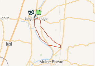
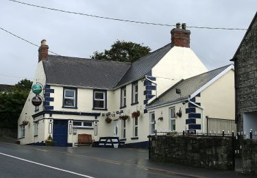
Tour Zu Fuß von 7,7 km verfügbar auf Unbekannt, County Carlow, The Municipal District of Muinebeag. Diese Tour wird von SityTrail - itinéraires balisés pédestres vorgeschlagen.
Beschreibung
Tour erstellt von Slí na Sláinte - Irish Heart Foundation.
Ort
Land:
Ireland
Region :
Unbekannt
Abteilung/Provinz :
County Carlow
Kommune :
The Municipal District of Muinebeag
Standort:
Leighlinbridge ED
Gehen Sie:(Dec)
Gehen Sie:(UTM)
636528 ; 5844844 (29U) N.
Kommentare
Touren in der Umgebung
![Tour Zu Fuß The Municipal District of Muinebeag - Rathanna Slí na Sláinte - Photo](https://media.geolcdn.com/t/375/260/027ab5df-7ee9-4de6-a8a8-c4d7d2918c44.jpeg&format=jpg&maxdim=2)
![Zu Fuß Zu Fuß](https://static1.geolcdn.com/sitytour/trail-icons/100.png)
Rathanna Slí na Sláinte
Zu Fuß
Einfach
The Municipal District of Muinebeag,
Unbekannt,
County Carlow,
Ireland
![](/images/other/stat-length.png)
5,4 km | 6,1 km-effort
1h 22min
![](https://static1.geolcdn.com/siteimages/upload/files/16400158638029165_repeat_loop_refresh_sync_direction_icon.png)
Ja
![Tour Zu Fuß The Municipal District of Kilkenny City - Nore Valley Walk - Photo](https://media.geolcdn.com/t/375/260/a0795b87-0de1-473a-bc60-47bc8f0672e3.jpeg&format=jpg&maxdim=2)
![Zu Fuß Zu Fuß](https://static1.geolcdn.com/sitytour/trail-icons/100.png)
Nore Valley Walk
Zu Fuß
Einfach
The Municipal District of Kilkenny City,
Unbekannt,
County Kilkenny,
Ireland
![](/images/other/stat-length.png)
9,6 km | 10,3 km-effort
2h 19min
![](https://static1.geolcdn.com/siteimages/upload/files/16400158638029165_repeat_loop_refresh_sync_direction_icon.png)
Nein
![Tour Zu Fuß The Municipal District of Muinebeag - Knockmullgurry Slí na Sláinte - Photo](https://media.geolcdn.com/t/375/260/a783b142-d39b-4cca-a7e9-d3077f4df79b.jpeg&format=jpg&maxdim=2)
![Zu Fuß Zu Fuß](https://static1.geolcdn.com/sitytour/trail-icons/100.png)
Knockmullgurry Slí na Sláinte
Zu Fuß
Einfach
The Municipal District of Muinebeag,
Unbekannt,
County Carlow,
Ireland
![](/images/other/stat-length.png)
7 km | 8,2 km-effort
1h 52min
![](https://static1.geolcdn.com/siteimages/upload/files/16400158638029165_repeat_loop_refresh_sync_direction_icon.png)
Nein
![Tour Zu Fuß The Municipal District of Muinebeag - Walshestown Slí na Slainte - Photo](https://media.geolcdn.com/t/375/260/a783b142-d39b-4cca-a7e9-d3077f4df79b.jpeg&format=jpg&maxdim=2)
![Zu Fuß Zu Fuß](https://static1.geolcdn.com/sitytour/trail-icons/100.png)
Walshestown Slí na Slainte
Zu Fuß
Einfach
The Municipal District of Muinebeag,
Unbekannt,
County Carlow,
Ireland
![](/images/other/stat-length.png)
7,5 km | 9,6 km-effort
2h 10min
![](https://static1.geolcdn.com/siteimages/upload/files/16400158638029165_repeat_loop_refresh_sync_direction_icon.png)
Ja